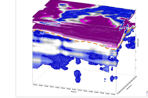
The georadar method, also known as GPR (Ground Penetrating Radar), belongs to a class of electromagnetic geophysical methods that analyze the changes of an electromagnetic wave injected into the ground. The transmitting antenna emits a wave in the subsurface that is reflected at the boundary between two layers having different dielectric constants and then is recorded by the receiving antenna. The energy of the reflected pulse is proportional to the difference between the dielectric constants of the two media.
One of the most popular ways of performing measurements using the GPR method is profiling. During this type of measurement, both antennas are moved along a previously marked measurement profile line. This type of research can also be performed in a 3D variant, in which the measurement profiles are arranged in a parallel grid.
The maximum depth of a measurement performed using a georadar depends on the frequency of the antenna used. A 250 MHz antenna can record useful information from a depth of about 6 m (in good measurement conditions). On the other hand, a 750 MHz antenna can be used to recognize medium to a depth of only about 1.5 m, but with very good centimeter resolution (accuracy).
GPR measurements are completely non-invasive. Thanks to this, they can be performed in nature reserves, inside buildings, in road and airport runway surveys, etc. This method allows for immediate, preliminary evaluation of results, already during field measurements. The measurement is fast and efficient (compared to other geophysical methods). Using GPRs designed for surveying roads, motorways, and railway lines, measurements can be performed at several dozen kilometers per hour. Modern models of GPR equipment are lightweight, ergonomic, and small in size.